RUS Webinar: Snow Cover Mapping with Sentinel-2 - CRYO03
RUS Webinar: Snow Cover Mapping with Sentinel-3 - CRYO05
RUS Webinar: Burned Area Mapping with Sentinel-2 - HAZA02
RUS Webinar: Crop Mapping with Sentinel-2 - LAND01
RUS Webinar: Vegetation monitoring for Agriculture with Sentinel-2 - LAND11
RUS Webinar: Drought Monitoring with Sentinel-2 - HYDR03
RUS Webinar: Lithological Classification with Sentinel-1 & Sentinel-2 - GEOL01
RUS Webinar: Coral Reef Monitoring with Sen2Coral - OCEA05
RUS Webinar: Lebanon Damage Assessment with Sentinel-1 & Sentinel-2 - HAZA08
RUS Webinar: Freshwater Quality Monitoring with Sentinel-2 - HYDR02
RUS Webinar: Deforestation Monitoring with Sentinel-2 - LAND08
RUS Webinar: Watching a Typhoon from space - HAZA06
Sentinel2 Satellite Imagery (for snow cover)
RUS Webinar: Land Monitoring with Sentinel-3 - LAND04
RUS Webinar: Sea Ice Monitoring with Sentinel-1 - CRYO04
RUS Webinar: Altimetry & Oceanography with the BRAT Toolbox - Part 2 - OCEA07
RUS Webinar: Processing Sentinel-2 data with R - R01
RUS Webinar: Fire Emissions Monitoring with Sentinel-5P - ATMO05
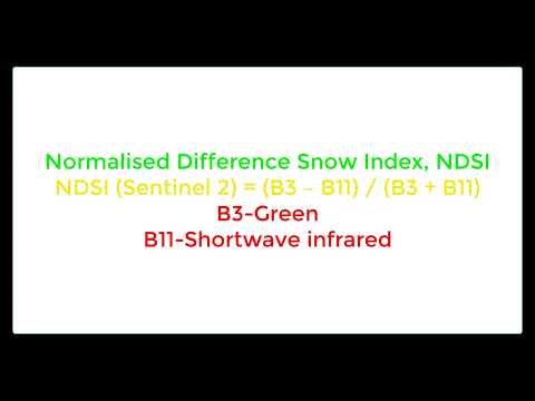
NDSI: Normalized Difference Snow Index Using sentile-2B
RUS Webinar: Glacier Velocity with Sentinel-1 - CRYO01